
Table of Contents

Every-Name Index
Table of Contents |
Diana, Goddess
of the Hunt for Ancestors!
|
Every-Name Index |
|
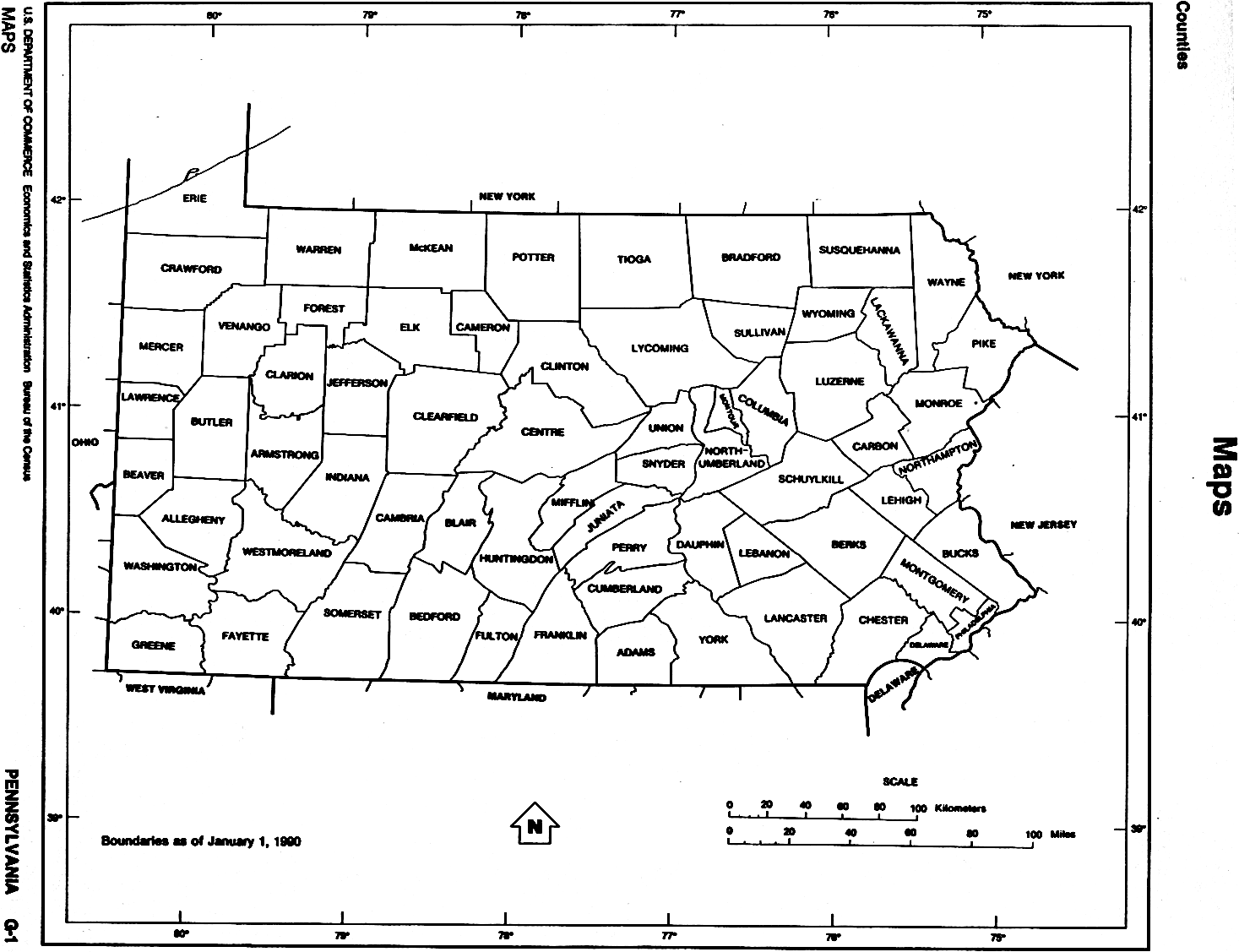
| Pennsylvania Geography
Formation of Counties Lists of Townships and Boroughs Links to Township Histories and Maps |
| - Adams - Allegheny - Armstrong - Beaver - Bedford - Berks - Blair - Bradford - Bucks - Butler - Cambria - Cameron - Carbon - Centre - Chester - Clarion - Clearfield - Clinton - Columbia - Crawford - Cumberland - Dauphin - Delaware - Elk - Erie - Fayette - Forest - Franklin - Fulton - Greene - Huntingdon - Indiana - Jefferson - Juniata - Lackawanna - Lancaster - Lawrence - Lebanon - Lehigh - Luzerne - Lycoming - McKean - Mercer - Mifflin - Monroe - Montgomery - Montour - Northampton - Northumberland - Perry - Philadelphia - Pike - Potter - Schuylkill - Snyder - Somerset - Sullivan - Susquehanna - Tioga - Union - Venango - Warren - Washington - Wayne - Westmoreland - Wyoming - York - |
|
| ADAMS COUNTY |
| FORMATION: 1800, from York Co.
TOWNSHIPS (as of 1990): Berwick, Butler, Conewago, Cumberland, Franklin, Freedom, Germany, Hamilton, Hamiltonban, Highland, Huntington, Latimore, Liberty, Manallen, Mount Joy, Mount Pleasant, Oxford, Reading, Straban, Tyrone, Union. BOROUGHS (as of 1990): Abbottstown, Arendtsville, Bendersville,
Biglerville, Bonneauville, Carroll Valley, East Berlin, Fairfield, Gettysburg,
Littlestown, McSherrystown, New Oxford, York Springs.
|
| ALLEGHENY COUNTY |
| FORMATION: 1786 from Washington and Westmoreland Cos.
TOWNSHIPS (as of 1990): Aleppo, Baldwin, Collier, Crescent, East Deer, Elizabeth, Fawn, Findlay, Forward, Frazer, Hampton, Harmar, Harrison, Indiana, Kennedy, Kilbuck, Leet, McCandless, Marshall, Moon, Mount Lebanon, Neville, North Fayette, North Versailles, O'Hara, Ohio, Penn Hills, Pine, Ross, Shaler, South Fayette, South Park, South Versailles, Springdale, Stowe, Upper St. Clair, West Deer, Wilkins. BOROUGHS (as of 1990): Aspinwall, Avalon, Baldwin, Bell Acres, Bellevue, Ben Avon, Ben Avon Heights, Bethel Park, Blawnox, Brackenridge, Braddock, Braddock Hills, Bradfordwoods, Brentwood, Bridgeville, Carnegie, Castle Shannon, Chalfant, Cheswick, Churchill, Clairton city, Coraopolis, Crafton, Dormont, Dravosburg, Duquesne city, East McKeesport, East Pittsburgh, Edgewood, Edgeworth, Elizabeth, Emsworth, Etna, Forest Hills, Fox Chapel, Franklin Park, Glassport, Glenfield, Green Tree, Haysville, Heidelberg, Homestead, Ingram, Jefferson, Leetsdale, Liberty, Lincoln, McDonald, McKees Rocks, Millvale, Municipality of Monroeville, Mount Oliver, Munhall, North Braddock, Oakdale, Oakmont, Osborne, Pennsbury Village, Pitcairn, Pittsburgh city, Pleasant Hills, Plum, Port Vue, Rankin, Rosslyn Farms, Sewickley, Sewickley Heights, Sewickley Hills, Sharpsburg, Springdale, Swissvale, Tarentum, Thornburg, Trafford, Turtle Creek, Verona, Versailles, Wall, West Elizabeth, West Homestead, West Mifflin, West View, Whitaker, Whitehall, White Oak, Wilkinsburg, Wilmerding. HISTORICAL: There was an Allegheny in the
1840 Census and an Allegheny City in the 1850 Census. According to
the USGS GNIS, there was an historical "Allegheny" which was incorporated
into the city of Pittsburg in 1907.
|
| ARMSTRONG COUNTY |
| FORMATION: 1800 from Allegheny, Lycoming, and Westmoreland.
TOWNSHIPS (as of 1990): Bethel, Boggs, Bradys Bend, Burrell, Cadogan, Cowanshannock, East Franklin, Gilpin, Hovey, Kiskiminetas, Kittanning, Madison, Mahoning, Manor, North Buffalo, Parks, Perry, Pine, Plumcreek, Rayburn, Redbank, South Bend, South Buffalo, Sugarcreek, Valley, Washington, Wayne, West Franklin. BOROUGHS (as of 1990): Apollo, Applewold, Atwood, Dayton, Elderton,
Ford City, Ford Cliff, Freeport, Kittanning, Leechburg, Manorville, North
Apollo, Parker city, Rural Valley, South Bethleham, West Kittanning, Worthington.
|
| BEAVER COUNTY |
| FORMATION: 1800 from Allegheny and Washington Cos.
TOWNSHIPS (as of 1990): Brighton, Center, Chippewa, Darlington, Daugherty, Franklin, Greene, Hanover, Harmony, Hopewell, Independence, Marion, New Sewickley, North Sewickley, Patterson, Potter, Pulaski, Raccoon, Rochester, South Beaver, Vanport, White. BOROUGHS (as of 1990): Aliquippa city, Ambridge, Baden, Beaver,
Beaver Falls city, Big Beaver, Bridgewater, Conway, Darlington, East Rochester,
Eastvale, Economy, Ellwood City, Fallston, Frankfort Springs, Freedom,
Georgetown, Glasgow, Homewood, Hookstown, Industry, Koppel, Midland, Monaca,
New Brighton, New Galilee, Ohioville, Patterson Heights, Rochester, Shippingport,
South Heights, West Mayfield.
|
| BEDFORD COUNTY |
| FORMATION: 1771 from Cumberland Co.
TOWNSHIPS (as of 1990): Bedford, Bloomfield, Broad Top, Colerain, Cumberland Valley, East Providence, East St. Clair, Harrison, Hopewell, Juniata, Kimmel, King, Liberty, Lincoln, Londonderry, Mann, Monroe, Napier, Snake Spring, Southampton, South Woodbury, Union, West Providence, West St. Clair, Woodbury. BOROUGHS (as of 1990): Bedford, Coaldale, Everett, Hopewell, Hyndman,
Manns Choice, New Paris, Pleasantville, Rainsburg, St. Clairsville, Saxton,
Schellsburg, Woodbury.
|
| BERKS COUNTY |
| FORMATION: 1752 from Chester, Lancaster, and Philadelphia Cos.
TOWNSHIPS (as of 1990): Albany, Alsace, Amity, Bern, Bethel, Brecknock, Caernarvon, Centre, Colebrookdale, Cumru, District, Douglass, Earl, Exeter, Greenwich, Heidelberg, Hereford, Jefferson, Longswamp, Lower Alsace, Lower Heidelberg, Maidencreek, Marion, Maxatawny, Muhlenberg, North Heidelberg, Oley, Ontelaunee, Penn, Perry, Pike, Richmond, Robeson, Rockland, Ruscombmanor, South Heidelberg, Spring, Tilden, Tulpehocken, Union, Upper Bern, Upper Tulpehocken, Washington, Windsor. BOROUGHS (as of 1990): Adamstown, Bally, Bechtelsville, Bernville, Birdsboro, Boyertown, Centerport, Fleetwood, Hamburg, Kenhorst, Kutztown, Laureldale, Leesport, Lenhartsville, Lyons, Mohnton, Mount Penn, Robesonia, St. Lawrence, Shillington, Shoemakersville, Sinking Spring, Strausstown, Temple, Topton, Wernersville, West Lawn, West Reading, Womelsdorf, Wyomissing, Wyomissing Hills. CITIES (as of 1990): Reading. HISTORICAL: there was a Reading Borough
in the 1790 Census.
|
| BLAIR COUNTY |
| FORMATION: 1846 from Bedford and Huntingdon Cos.
TOWNSHIPS (as of 1990): Allegheny, Antis, Blair, Catharine, Frankstown, Freedom, Greenfield, Huston, Juniata, Logan, North Woodbury, Snyder, Taylor, Tyrone, Woodbury. BOROUGHS (as of 1990): Altoona city, Bellwood, Duncansville, Hollidaysburg,
Martinsburg, Newry, Roaring Spring, Tunnelhill, Tyrone, Williamsburg.
|
| BRADFORD COUNTY |
| FORMATION: 1810 from Luzerne and Lycoming Cos.
TOWNSHIPS (as of 1990): Albany (1824 fr Asylum), Armenia (1843 fr Troy and Canton), Asylum, Athens, Burlington (1801 fr Wysox), Canton, Columbia, Franklin, Granville, Herrick, Leroy, Litchfield, Monroe (1820 fr Towanda), North Towanda, Orwell, Overton, Pike, Ridgebury, Rome (1830 fr Sheshequin, Orwell, Wysox), Sheshequin, Smithfield, South Creek, Springfield, Standing Stone, Stevens, Terry, Towanda (1808 fr Wyalusing), Troy, Tuscarora, Ulster, Warren (1813 fr Orwell), Wells, West Burlington, Wilmot, Windham, Wyalusing (1790 fr Stoke), Wysox (1795 fr Tioga). BOROUGHS (as of 1990): Alba, Athens,
Burlington, Canton, Le Raysville, Monroe, New Albany, Rome, Sayre, South
Waverly, Sylvania, Towanda, Troy, Wyalusing.
|
| BUCKS COUNTY |
| FORMATION: 1682 from Amerindian territory.
TOWNSHIPS (as of 1990): Bedminster, Bensalem, Bridgeton, Bristol, Buckingham, Doylestown, Durham, East Rockhill, Falls, Haycock, Hilltown, Lower Makefield, Lower Southampton, Middltown, Milford, New Britain, Newtown, Nockamixon, Northampton, Plumstead, Richland, Solebury, Springfield, Tinicum, Upper Makefield, Upper Southampton, Warminster, Warrington, Warwick, West Rockhill, Wrightstown. BOROUGHS (as of 1990): Bristol, Chalfont, Doylestown, Dublin,
Hulmeville, Ivyland, Langhorne, Langhorne Manor, Morrisville, New Britain,
New Hope, Newtown, Penndel, Perkasie, Quakertown, Richlandtown, Riegelsville,
Sellersville, Silverdale, Telford, Trumbauersville, Tullytown, Yardley.
|
| BUTLER COUNTY |
| FORMATION: 1800 from Allegheny Co.
TOWNSHIPS (as of 1990): Adams, Allegheny, Brady, Buffalo, Butler, Center, Cherry, Clay, Clearfield, Clinton, Concord, Connoquenessing, Cranberry, Donegal, Fairview, Forward, Franklin, Jackson, Jefferson, Lancaster, Marion, Mercer, Middlesex, Mudddy Creek, Oakland, Parker, Penn, Slippery Rock, Summit, Venango, Washington, Winfield, Worth. BOROUGHS (as of 1990): Bruin, Butler city, Callery, Cherry Valley,
Chicora, Connoquenessing, East Butler, Eau Claire, Evans City, Fairview,
Harmony, Harrisville, Karns City, Mars, Petrolia, Portersville, Prospect,
Saxonburg, Seven Fields, Slippery Rock, Valencia, West Liberty, West Sunbury,
Zelienople.
|
| CAMBRIA COUNTY |
| FORMATION: 1804 from Bedford, Huntingdon, and Somerset Cos.
TOWNSHIPS (as of 1990): Adams Allegheny, Barr, Blacklick, Cambria, Chest, Clearfield, Conemaugh, Cresson, Croyle, Dean, East Carroll, East Taylor, Elder, Gallitzin, Jackson, Lower Yoder, Middle Taylor, Munster, Portage, Reade, Richland, Stonycreek, Summerhill, Susquehanna, Upper Yoder, Washington, West Carroll, West Taylor, White. BOROUGHS (as of 1990): Ashville, Barnesboro, Brownstown, Carrolltown,
Cassandra, Chest Springs, Cresson, Daisytown, Dale, East Conemaugh, Ebensburg,
Ehrenfeld, Ferndale, Franklin, Gallitzin, Geistown, Hastings, Johnstown
city, Lilly, Lorain, Loretto, Nanty-Glo, Patton, Portage, Sankertown, Scalp
Level, South Fork, Southmont, Spangler, Summerhill, Tunnelhill, Vintondale,
Westmont, Wilmore.
|
| CAMERON COUNTY |
| FORMATION: 1860 from Clinton, Elk, McKean, and Potter Cos.
TOWNSHIPS (as of 1990): Gibson, Grove, Lumber, Portage, Shippen. BOROUGHS (as of 1990): Driftwood, Emporium.
|
| CARBON COUNTY |
| FORMATION: 1843 from Monroe and Northampton Cos.
TOWNSHIPS (as of 1990): Banks, East Penn, Franklin, Kidder, Lausanne, Lehigh, Lower Towamensing, Mahoning, Packer, Penn Forest, [Upper] Towamensing. BOROUGHS (as of 1990): Beaver Meadows, Bowmanstown, East Side, Jim Thorpe, Lansford, Lehighton, Nesquehoning, Palmerton, Parryville, Summit Hill, Weatherly, Weissport. HISTORICAL: In 1840, Lower Towamensing was split off from Towamensing;
afterwards, Towamensing was sometimes called "Upper Towamensing," though
that is not its official name. Mauch Chunk
Twp. was formed in 1827 from East Penn. Mauch Chunk was gradually
whittled out of existence by the formation of boroughs: Lansford
in 1876, Summit Hill in 1889, Jim Thorpe (formerly Mauch Chunk and East
Mauch Chunk Boroughs) in 1954, and Nesquehoning ca. 1963, at which point
Mauch Chunk became extinct. See detailed history at the link below.
|
| CENTRE COUNTY |
| FORMATION: 1800 from Huntingdon, Lycoming, Mifflin, and Northumberland
Cos.
TOWNSHIPS (as of 1990): Benner, Boggs, Burnside, College, Curtin, Ferguson, Gregg, Haines, Halfmoon, Harris, Howard, Huston, Liberty, Marion, Miles, Patton, Penn, Potter, Rush, Snow Shoe, Spring, Taylor, Union, Walker, Worth. BOROUGHS (as of 1990): Bellefonte,
Centre Hall, Howard, Milesburg, Millheim, Philipsburg, Port Matilda, Snow
Shoe, South Philipsburg, State College, Unionville.
|
| CHESTER COUNTY |
| FORMATION: 1682 from Amerindian territory.
TOWNSHIPS (as of 1990): Birmingham, Caln, Charlestown, East Bradford, East Brandywine, East Caln, East Coventry, East Fallowfield, East Goshen, East Marlborough, East Nantmeal, East Nottingham, East Pikeland, Easttown, East Vincent , East Whiteland, Elk, Franklin, Highland, Honey Brook, Kennett, London Britain, Londonderry, London Grove, Lower Oxford, New Garden, Newlin, New London, North Coventry, Penn, Pennsbury, Pocopson, Sadsbury, Schuylkill, South Coventry, Thornbury, Tredyffrin, Upper Oxford, Upper Uwchlan, Uwchlan, Valley, Wallace, Warwick, West Bradford, West Brandywine, West Caln, West Fallowfield, West Goshen, West Marlborough, West Nantmeal, West Nottingham, West Pikeland, West Sadsbury, Westtown, West Vincent, West Whiteland, Willistown. HISTORICAL: There is a Coventry Twp. in the 1790 Census; presumably this Coventry Twp. was later divided into the three Coventry townships above. BOROUGHS (as of 1990): Atglen, Avondale, Coatesville City, Downingtown,
Elverson, Honey Brook, Kennett Square, Malvern, Modena, Oxford, Parkesburg,
Phoenixville, South Coatesville, Spring City, West Chester, West Grove.
|
| CLARION COUNTY |
| FORMATION: 1839 from Armstrong and Venango Cos.
TOWNSHIPS (as of 1990): Ashland, Beaver, Brady, Clarion, Elk, Farmington, Highland, Knox, Licking, Limestone, Madison, Millcreek, Monroe, Paint, Perry, Piney, Porter, Redbank, Richland, Salem, Toby, Washington. BOROUGHS (as of 1990): Callensburg, Clarion, East Brady, Emlenton,
Foxburg, Hawthorn, Knox, New Bethlehem, Rimersburg, St. Petersburg, Shippenville,
Sligo, Strattanville.
|
| CLEARFIELD COUNTY |
| FORMATION: 1804 from Huntingdon and Lycoming Cos.
TOWNSHIPS (as of 1990): Beccaria, Bell, Bigler, Bloom, Boggs, Bradford, Brady, Burnside, Chest, Cooper, Covington, Decatur, Ferguson, Girard, Goshen, Graham, Greenwood, Gulich, Huston, Jordan, Karthaus, Knox, Lawrence, Morris, Penn, Pike, Pine, Sandy, Union, Woodward. BOROUGHS (as of 1990): Brisbin, Burnside, Chester Hill, Clearfield,
Coalport, Curwensville, DuBois city, Falls Creek, Glen Hope, Grampian,
Houtzdale, Irvona, Lumber City, Mahaffey, Newburg, New Washington, Osceola
Mills, Ramey, Troutville, Wallaceton, Westover.
|
| CLINTON COUNTY |
| FORMATION: 1839 from Centre and Lycoming Cos.
TOWNSHIPS (as of 1990): Allison, Bald Eagle, Beech Creek, Castanea, Chapman, Colebrook, Crawford, Dunnstable, East Keating, Gallagher, Greene, Grugan, Lamar, Leidy, Logan, Noyes, Pine Creek, Porter, Wayne, West Keating, Woodward. BOROUGHS (as of 1990): Avis, Beech Creek, Flemington, Lock
Haven city, Loganton, Mill Hall, Renovo, South Renovo.
|
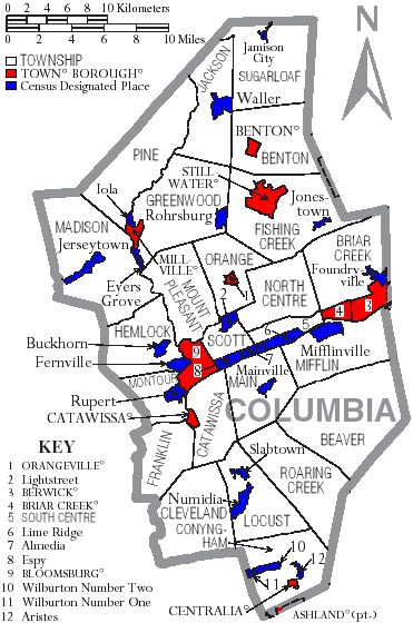
| COLUMBIA COUNTY |
| FORMATION: 1813 from Northumberland Co.
TOWNSHIPS (as of 1990): Beaver, Benton, Briar Creek, Catawissa, Cleveland, Conyngham, Fishing Creek, Franklin, Greenwood, Hemlock, Jackson, Locust, Madison, Main, Mifflin, Montour, Mount Pleasant, North Centre, Orange, Pine, Roaring Creek, Scott, South Centre, Sugarloaf. BOROUGHS (as of 1990): Ashland Benton, Berwick, Bloomsburg town,
Briar Creek, Catawissa, Centralia, Millville, Orangeville, Stillwater.
|
| CRAWFORD COUNTY |
| FORMATION: 1800 from Allegheny Co.
TOWNSHIPS (as of 1990): Athens, Beaver, Bloomfield, Cambridge, Conneaut, Cussewago, East Fairfield, East Fallowfield, East Mead, Fairfield, Greenwood, Hayfield, North Shenango, Oil Creek, Pine, Randolph, Richmond, Rockdale, Rome, Sadsbury, South Shenango, Sparta, Spring, Steuben, Summerhill, Summit, Troy, Union, Venango, Vernon, Wayne, West Fallowfield, West Mead, West Shenango, Woodcock. BOROUGHS (as of 1990): Blooming Valley, Cambridge Springs, Centerville,
Cochranton, Conneaut Lake, Conneautville, Hydetown, Linesville, Meadville
city, Saegertown, Spartansburg, Springboro, Titusville city, Townville,
Venango, Woodcock.
|
| CUMBERLAND COUNTY |
| FORMATION: 1750 from Lancaster Co. and unincorporated territory.
After 1788, the only change to the county boundaries of Cumberland Co.
was the loss to form Perry Co. in 1820.
TOWNSHIPS (as of 1990): Cooke, Dickinson, East Pennsboro, Hampden, Hopewell, Lower Allen, Lower Frankford, Lower Mifflin, Middlesex, Monroe, North Middleton, North Newton, Penn, Shippensburg, Silver Spring, Southampton, South Middleton, South Newton, Upper Allen, Upper Frankford, Upper Mifflin, West Pennsboro. BOROUGHS (as of 1990): Camp Hill, Carlisle, Lemoyne, Mechanicsburg, Mount Holly Springs, Newburg, New Cumberland, Newville, Shippensburg, Shiremans, West Fairview, Wormleysburg. HISTORICAL: Middleton was spit into North and South in 1810; Allen
into Upper and Lower in 1850; Mifflin into Upper and Lower in 1892; Frankford
into Lower and Upper in 1929; Newton into North and South in 1929.
|
| DAUPHIN COUNTY |
| FORMATION: 1785 from Lancaster Co.
TOWNSHIPS (as of 1990): Conewago, Derry, East Hanover, Halifax, Jackson, Jefferson, Londonderry, Lower Paxton, Lower Swatara, Lykens, Middle Paxton, Mifflin, Reed, Rush, South Hanover, Susquehanna, Swatara, Upper Paxton, Washington, Wayne, West Hanover, Wiconisco, Williams. BOROUGHS (as of 1990): Berrysburg, Dauphin, Elizabethville, Gratz,
Halifax, Harrisburg city, Highspire, Hummelstown, Lykens, Middletown, Millersburg,
Paxtang, Penbrook, Pillow, Royalton, Steelton, Williamstown.
|
| DELAWARE COUNTY |
| FORMATION: 1789 from Chester Co.
TOWNSHIPS (as of 1990): Aston, Bethel, Birmingham, Chester, Concord, Darby, Edgmont, Haverford, Lower Chichester, Marple, Middletown, Nether Providence, Newtown, Radnor, Ridley, Springfield, Thornbury, Tinicum, Upper Chichester, Upper Darby, Upper Providence. BOROUGHS (as of 1990): Aldan, Brookhaven, Chester city, Chester
Heights, Clifton Heights, Collingdale, Colwyn, Darby, East Lansdowne, Eddystone,
Folcroft, Glenolden, Lansdowne, Marcus Hook, Media, Millbourne, Morton,
Norwood, Parkside, Prospect Park, Ridley Park, Rose Valley, Rutledge, Sharon
Hill, Swarthmore, Trainer, Upland, Yeadon.
|
| ELK COUNTY |
| FORMATION: 1843 from Clearfield, Jefferson, and McKean Cos.
TOWNSHIPS (as of 1990): Benezette, Benzinger, Fox, Highland, Horton, Jay, Jones, Millstone, Ridgway, Spring Creek. BOROUGHS (as of 1990): Johnsonburg, Ridgway, St. Marys.
|
| ERIE COUNTY |
| FORMATION: 1800 from Allegheny and Crawford Cos.
TOWNSHIPS (as of 1990): Amity, Concord, Conneaut, Elk Creek, Fairview, Franklin, Girard, Greene, Greenfield, Harborcreek, Lawrence Park, Le Boeuf, McKean, Millcreek, North East, Springfield, Summit, Union, Venango, Washington, Waterford, Wayne. BOROUGHS (as of 1990): Albion, Corry city, Cranesville, Edinboro,
Elgin, Erie city, Fairview, Girard, Lake City,
McKean, Mill Village, North East, Platea, Union City, Waterford, Wattsburg,
Wesleyville.
|
| FAYETTE COUNTY |
| FORMATION: 1783 from Westmoreland Co.
TOWNSHIPS (as of 1990): Brownsville, Bullskin, Connellsville, Dunbar, Franklin, Georges, German, Henry Clay, Jefferson, Lower Tyrone, Luzerne, Menallen, Nicholson, North Union, Perry, Redstone, Saltlick, South Union, Springfield, Springhill, Stewart, Upper Tyrone, Washington, Wharton. BOROUGHS (as of 1990): Belle Vernon, Brownsville, Connellsville city, Dawson, Dunbar, Everson, Fairchance, Fayette City, Markleysburg, Masontown, Newell, Ohiopyle, Perryopolis, Point Marion, Seven Springs, Smithfield, South Connellsville, Uniontown city, Vanderbilt. HISTORICAL: There was a Union Borough
in the 1840 Census is this now Uniontown?
|
| FOREST COUNTY |
| FORMATION: officially created in 1848 from Jefferson and Venango
Cos., but not functional until 1857; gained considerably from Venango in
1865.
TOWNSHIPS (as of 1990): Barnett, Green, Harmony, Hickory, Howe, Jenks, Kingsley, Tionesta. BOROUGHS (as of 1990): Tionesta.
|
| FRANKLIN COUNTY |
| FORMATION: 1784 from Cumberland Co.
TOWNSHIPS (as of 1990): Antrim, Fannett, Greene, Guilford, Hamilton, Letterkenny, Lurgan, Metal, Montgomery, Peters, Quincy, St. Thomas, Southampton, Warren, Washington. BOROUGHS (as of 1990): Chambersburg, Greencastle, Mercersburg,
Mont Alto, Orrstown, Shippensburg, Waynesboro.
|
| FULTON COUNTY |
| FORMATION: 1850 from Bedford Co.
TOWNSHIPS (as of 1990): Ayr, Belfast, Bethel, Brush Creek, Dublin, Licking Creek, Taylor, Thompson, Todd, Union, Wells. BOROUGHS (as of 1990): McConnellsburg, Valley-Hi.
|
| GREENE COUNTY |
| FORMATION: 1796 from Washington Co.
TOWNSHIPS (as of 1990): Aleppo, Center, Cumberland, Dunkard, Franklin, Freeport, Gilmore, Gray, Greene, Jackson, Jefferson, Monongahela, Morgan, Morris, Perry, Richhill, Springhill, Washington, Wayne, Whiteley. BOROUGHS (as of 1990): Carmichaels, Clarksville, Greensboro, Jefferson,
Rices Landing, Waynesburg.
|
| HUNTINGDON COUNTY |
| FORMATION: 1787 from Bedford Co.
TOWNSHIPS (as of 1990): Barree, Brady, Carbon, Cass, Clay, Cromwell, Dublin, Franklin, Henderson, Hopewell, Jackson, Juniata, Lincoln, Logan, Miller, Morris, Oneida, Penn, Porter, Shirley, Smithfield, Springfield, Spruce Creek, Tell, Todd, Union, Walker, Warriors Mark, West, Wood. BOROUGHS (as of 1990): Alexandria, Birmingham, Broad Top City, Cassville, Coalont, Dudley, Huntingdon, Mapleton, Marklesburg, Mill Creek, Mount Union, Orbisonia, Petersburg, Rockhill Furnace, Saltillo, Shade Gap, Shirleysburg, Three Springs. HISTORICAL: There is a Woodberry Twp.
in the 1840 Census.
|
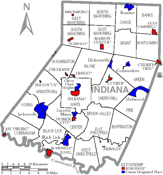
| INDIANA COUNTY |
| FORMATION: 1803 from Lycoming and Westmoreland Cos.
TOWNSHIPS (as of 1990): Armstrong, Banks, Black Lick, Brush Valley, Buffington, Burrell, Canoe, Center, Cherryhill, Conemaugh, East Mahoning, East Wheatfield, Grant, Green, Montgomery, North Mahoning, Pine, Rayne, South Mahoning, Washington, West Mahoning, West Wheatfield, White, Young. BOROUGHS (as of 1990): Armagh, Blairsville, Cherry Tree, Clymer,
Creekside, Ernest, Glen Campbell, Homer City, Indiana, Jacksonville, Marion
Center, Plumville, Saltsburg, Shelocta, Smicksburg.
|
| JEFFERSON COUNTY |
| FORMATION: 1804 from Lycoming Co.
TOWNSHIPS (as of 1990): Barnett, Beaver, Bell, Clover, Eldred, Gaskill, Heath, Henderson, Knox, McCalmont, Oliver, Perry, Pine Creek, Polk, Porter, Ringgold, Rose, Snyder, Union, Warsaw, Washington, Winslow, Young. BOROUGHS (as of 1990): Big Run, Brockway, Brookville, Corsica,
Falls Creek, Punxsutawney, Reynoldsville, Summerville, Sykesville, Timblin,
Worthville.
|
| JUNIATA COUNTY |
| FORMATION: 1831 from Mifflin Co. From 1750 to 1789,
the area that would become Juniata Co. was in Cumberland Co. From
1789 to 1831, it was in Mifflin Co. In 1831, Juniata Co. was formed
from southern and eastern Mifflin Co., and its boundaries have not changed
since.
TOWNSHIPS (as of 1990): Beale, Delaware, Fayette, Fermanagh, Greenwood, Lack, Milford, Monroe, Spruce Hill, Susquehanna, Turbett, Tuscarora, Walker. BOROUGHS (as of 1990): Mifflin, Mifflintown, Port Royal, Thompsontown. NOTE: Greenwood Twp. was formed in 1767 in Cumberland County.
The township was split in two in 1789 when Mifflin Co. was formed from
Cumberland County. In 1820, Perry Co. was formed from Cumberland
Co. and included Cumberland's part of Greenwood Twp.; in 1831, Juniata
Co. was formed from Mifflin Co. and included Mifflin's part of Greenwood
Twp. Obviously, the two Greenwood Twps. are adjacent and are, today,
on opposite sides of the Perry-Juniata county line. In 1858, Susquehanna
Twp. was formed from Greenwood.
|
| LACKAWANNA COUNTY |
| FORMATION: 1870 from Luzerne Co.
TOWNSHIPS (as of 1990): Abington, Benton, Carbondale, Clifton, Covington, Elmhurst, Fell, Glenburn, Greenfield, Jefferson, La Plume, Lehigh, Madison, Newton, North Abington, Ransom, Roaring Brook, Scott, South Abington, Spring Brook, West Abington. BOROUGHS (as of 1990): Archbald, Blakely, Carbondale city, Clarks
Green, Clarks Summit, Dalton, Dickson City, Dunmore, Jermyn, Jessup, Mayfield,
Moosic, Moscow, Old Forge, Olyphant, Scranton city, Taylor, Throop, Vandling.
|
| LANCASTER COUNTY |
| FORMATION: 1729 from Chester Co.
TOWNSHIPS (as of 1990): Bart, Brecknock, Caernarvon, Clay, Colerain, Conestoga, Conoy, Drumore, Earl, East Cocalico, East Donegal, East Drumore, East Earl, East Hempfield, East Lampeter, Eden, Elizabeth, Ephrata, Fulton, Lancaster, Leacock, Little Britain, Manheim, Manor, Martic, Mount Joy, Paradise, Penn, Pequea, Providence, Rapho, Sadsbury, Salisbury, Strasburg, Upper Leacock, Warwick, West Cocalico, West Donegal, West Earl, West Hempfield, West Lampeter. TOWNSHIP HISTORY: There was a Cocalico Twp. in Lancaster Co. in the 1830 Census, which was presumably divided into the East and West Cocalico Twps. above. There was a Lampeter Twp. in Lancaster Co. in the 1830 Census, which was presumably divided into the East and West Lampeter Twps. above. BOROUGHS (as of 1990): Adamstown, Akron, Christiana, Columbia, Denver, East Petersburg, Elizabethtown, Ephrata, Lancaster City, Lititz, Manheim, Marietta, Millersville, Mount Joy, Mountville, New Holland, Quarryville, Strasburg, Terre Hill. HISTORICAL: there was a May Town in the 1790 Census, and the GNIS
shows a Maytown in Lancaster Co. (I guess it doesn't qualify as a "borough").
|
| LAWRENCE COUNTY |
| FORMATION: 1849 from Beaver and Mercer Cos.
TOWNSHIPS (as of 1990): Hickory, Little Beaver, Mahoning, Neshannock, New Beaver, North Beaver, Perry, Plain Grove, Pulaski, Scott, Shenango, Slippery Rock, Taylor, Union, Washington, Wayne, Wilmington. BOROUGHS (as of 1990): Bessemer, Ellport, Ellwood City, Enon Valley,
New Beaver, New Castle, New Wilmington, S.N.P.J., South New Castle, Volant,
Wampum.
|
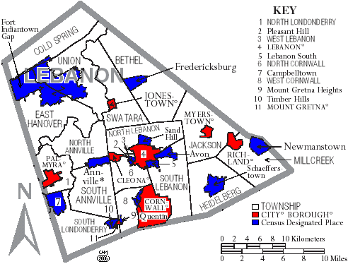
| LEBANON COUNTY |
| FORMATION: 1813, mostly from Dauphin Co., with a very small portion
from Lancaster Co.
TOWNSHIPS (as of 1990): Annville, Bethel, Cold Spring, East Hanover, Heidelberg, Jackson, Millcreek, North Annville, North Cornwall, North Lebanon, North Londonderry, South Annville, South Lebanon, South Londonderry, Swatara, Union, West Cornwall, West Lebanon. BOROUGHS (as of 1990): Cleona, Cornwall, Jonestown,
City of Lebanon, Mount Gretna, Myerstown, Palmyra, Richland.
|
| LEHIGH COUNTY |
| FORMATION: 1812 from Northampton Co.
TOWNSHIPS (as of 1990): Hanover, Heidelberg, Lower Macungie, Lower Milford, Lowhill, Lynn, North Whitehall, Salisbury, South Whitehall, Upper Macungie, Upper Milford, Upper Saucon, Washington, Weisenberg, Whitehall. TOWNSHIP HISTORY: There is a MacungieTwp. in the 1830 Census of Lehigh Co., which was presumably divided into the Upper and Lower Macungie Twps. above. BOROUGHS (as of 1990): Alburtis, Allentown
City,
Bethlehem City, Catasauqua, Coopersburg, Coplay, Emmaus, Fountain Hill,
Macungie, Slatington.
|
| LUZERNE COUNTY |
| FORMATION: 1786 from Northumberland Co.
TOWNSHIPS (as of 1990): Bear Creek, Black Creek, Buck, Butler, Conyngham, Dallas, Dennison, Dorrance, Exeter, Fairmount, Fairview, Foster, Franklin, Hanover, Hazle, Hollenback, Hunlock, Huntington, Jackson, Jenkins, Kingston, Lake, Lehman, Nescopeck, Newport, Pittston, Plains, Plymouth, Rice, Ross, Salem, Slocum, Sugarloaf, Union, Wilkes-Barre, Wright. BOROUGHS (as of 1990): Ashley, Avoca, Conyngham, Courtdale, Dallas,
Dupont, Duryea, Edwardsville, Exeter, Forty Fort, Freeland, Harveys Lake,
Hazleton city, Hughestown, Jeddo, Kingston, Laflin, Larksville, Laurel
Run, Luzerne, Nanticoke city, Nescopeck, New Columbus, Nuangola, Penn Lake
Park, Pittston city, Plymouth, Pringle, Shickshinny, Sugar Notch, Swoyersville,
Warrior Run, West Hazleton, West Pittston, West Wyoming, White Haven, Wilkes-Barre
city, Wyoming, Yatesville.
|
| LYCOMING COUNTY |
| FORMATION: 1795 from Northumberland Co.
TOWNSHIPS (as of 1990): Anthony, Armstrong, Bastress, Brady, Brown, Cascade, Clinton, Cogan House, Cummings, Eldred, Fairfield, Franklin, Gamble, Hepburn, Jackson, Jordan, Lewis, Limestone, Loyalsock, Lycoming, McHenry, McIntyre, McNett, Mifflin, Mill Creek, Moreland, Muncy, Muncy Creek, Nippenose, Old Lycoming, Penn, Piatt, Pine, Plunketts Creek, Porter, Shrewsbury, Susquehanna, Upper Fairfield, Washington, Watson, Wolf, Woodward. BOROUGHS (as of 1990): Duboistown, Hughesville, Jersey Shore,
Montgomery, Montoursville, Muncy, Picture
Rocks, Salladasburg, South Williamsport, Williamsport city.
|
| McKEAN COUNTY |
| FORMATION: 1804 from Lycoming Co.
TOWNSHIPS (as of 1990): Annin, Bradford, Ceres, Corydon, Eldred, Foster, Hamilton, Hamlin, Keating, Lafayette, Liberty, Norwich, Otto, Sergeant, Wetmore. BOROUGHS (as of 1990): Bradford city, Eldred, Kane, Lewis Run, Mount Jewett, Port Allegany, Smethport. HISTORICAL BOROUGHS: Kendall (see 1880 census). RESEARCH NOTES: In the 1860 census, all of Annin Twp. and the
first 98 pages of Bradford Twp., are missing at both Ancestry.com and Genealogy.com.
|
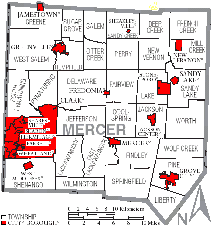
| MERCER COUNTY |
| FORMATION: 1800 from Allegheny and Crawford Cos.
TOWNSHIPS (as of 1990): Coolspring, Deer Creek, Delaware, East Lackawannock, Fairview, Findley, French Creek, Greene, Hempfield, Jackson, Jefferson, Lackawannock, Lake, Liberty, Mill Creek, New Vernon, Otter Creek, Perry, Pine, Pymatuning, Salem, Sandy Creek, Sandy Lake, Shenango, South Pymatuning, Springfield, Sugar Grove, West Salem, Wilmington, Wolf Creek, Worth. BOROUGHS (as of 1990): Clark, Farrell city, Fredonia, Greenville,
Grove City, Hermitage city, Jackson Center, Jamestown, Mercer, New Lebanon,
Sandy Lake, Sharon city, Sharpsville, Sheakleyville, Stoneboro, West Middlesex,
Wheatland.
|
| MIFFLIN COUNTY |
| FORMATION: 1789 from Cumberland and Northumberland Cos.
TOWNSHIPS (as of 1990): Armagh, Bratton, Brown, Decatur, Derry, Granville, Menno, Oliver, Union, Wayne. TOWNSHIPS - HISTORICAL: in 1789, in the area that would become today's (smaller) Mifflin Co., there existed just three townships: Armagh, Derry, and Wayne. Formation: Derry (1767, original county), Armagh (1770 from Derry), Wayne (1782 from Derry), Union (1790 from Armagh), Decatur (1813 from Derry), Oliver (1835 from Wayne), Brown (1837 from Armagh), Menno (1837 from Union), Granville (1838 from Oliver?), Bratton (1859 from Oliver). BOROUGHS (as of 1990): Burnham, Juniata Terrace, Kistler, Lewistown,
McVeytown.
|
| MONROE COUNTY |
| FORMATION: 1836 from Northampton and Pike Cos.
TOWNSHIPS (as of 1990): Barrett, Chestnuthill, Coolbaugh, Eldred, Hamilton, Jackson, Middle Smithfield, Paradise, Pocono, Polk, Price, Ross, Smithfield, Stroud, Tobyhanna, Tunkhannock. TOWNSHIP HISTORY: There is a Lower Smithfield in the 1790 and 1810 Censuses of Northampton Co., which is presumably the Smithfield Twp. now in Monroe Co. there are presently no other Smithfield Twps. in Northampton or counties derived from it. BOROUGHS (as of 1990): Delaware Water Gap, East Stroudsburg, Mount
Pocono, Stroudsburg.
|
| MONTGOMERY COUNTY |
| FORMATION: 1784 from Philadelphia Co.
TOWNSHIPS (as of 1990): Abington, Cheltenham, Douglass, East Norriton, Franconia, Hatfield, Horsham, Limerick, Lower Frederick, Lower Gwynedd, Lower Merion, Lower Moreland, Lower Pottsgrove, Lower Providence, Lower Salford, Marlborough, Montgomery, New Hanover, Perkiomen, Plymouth, Salford, Skippack, Springfield, Towamencin, Upper Dublin, Upper Frederick, Upper Gwynedd, Upper Hanover, Upper Merion, Upper Moreland, Upper Pottsgrove, Upper Providence, Upper Salford, West Norriton, West Pottsgrove, Whitemarsh, Whitpain, Worcester. BOROUGHS (as of 1990): Ambler, Bridgeport, Bryn Athyn, Collegeville, Conshohocken, East Greenville, Green Lane, Hatboro, Hatfield, Jenkintown, Lansdale, Narberth, Norristown, North Wales, Pennsburg, Pottstown, Red Hill, Rockledge, Royersford, Schwenksville, Souderton, Telford, Trappe, West Conshohocken. HISTORICAL: There was a Gwynedd Twp.
in the 1850 Census, which was presumably later divided into Upper and Lower
Gwynedd Twps.
|
| MONTOUR COUNTY |
| FORMATION: 1850 from Columbia Co.
TOWNSHIPS (as of 1990): Anthony, Cooper, Derry, Liberty, Limestone, Mahoning, Mayberry, Valley, West Hemlock. BOROUGHS (as of 1990): Danville,
Washingtonville.
|
| NORTHAMPTON COUNTY |
| FORMATION: 1752 from Bucks Co.
TOWNSHIPS (as of 1990): Allen, Bethlehem, Bushkill, East Allen, Forks, Hanover, Lehigh, Lower Mount Bethel, Lower Nazareth, Lower Saucon, Moore, Palmer, Plainfield, Upper Mount Bethel, Upper Nazareth, Washington, Williams. BOROUGHS (as of 1990): Bangor, Bath, Bethlehem city, Chapman, East Bangor, Easton city, Freemansburg, Glendon, Hellertown, Nazareth, Northampton, North Catasauqua, Pen Argyl, Portland, Roseto, Stockertown, Tatamy, Walnutport, West Easton, Wilson, Wind Gap. HISTORICAL: There is a "Bushkill Ward Boro"
in the 1840 Census.
|
| NORTHUMBERLAND COUNTY |
| FORMATON: 1772 from Bedford, Berks, Cumberland, Lancaster, and
Northampton Cos.
TOWNSHIPS (as of 1990): Coal, Delaware, East Cameron, East Chillisquaque, Jackson, Jordan, Lewis, Little Mahanoy, Lower Augusta, Lower Mahanoy, Mount Carmel, Point, Ralpho, Rockefeller, Rush, Shamokin, Turbot, Upper Augusta, Upper Mahanoy, Washington, West Cameron, West Chillisquaque, Zerbe. TOWNSHIP HISTORY (Bell 1891): Northumberland Co. ceded the following townships in 1813: to Columbia Co. went Bloom, Brier Creek, Catawissa, Chillisquaque, Derry, Fishing Creek, Greenwood, Hemlock, Mahoning, Mifflin, Sugar Loaf, and Turbot; to Union Co. went Beaver, Buffalo, Centre, Hartley, Mahantango, Penn, West Buffalo, and White Deer. In 1815, Turbot and Chillisquaque were reannexed to Northumberland. "Turbot" is the current official spelling, but you will often see it spelled "Turbut" or "Turbet" in historical documents. (The Washington Twp. in Snyder Co., today, was formed in 1818 from Penn Twp. while in Union Co., i.e., the Washington Twp. currently in Snyder Co. was a new creation and not originally part of the Washington Twp. currently in Northumberland Co.) In the 1830 Census, there was an Augusta Twp. in Northumberland Co. Presumably, this township was later divided into the Upper and Lower Augusta Twps. above. Ditto Chillisquaque, into East and West sections, which also occurs in the 1840 Census. BOROUGHS (as of 1990): Herndon, Kulpmont, McEwensville, Marion Heights, Milton, Mount Carmel, Northumberland, Riverside, Shamokin City, Snydertown, Sunbury City, Turbotville, Watsontown. REFERENCE: Herbert C. Bell. 1891. History of Northumberland
County... Brown, Runk & Co., Chicago. Detailed evolution
of county and townships, with a series of historical maps. Text
of book online at the PAGenWeb Northumberland Co. web site.
|
| PERRY COUNTY |
| FORMATION: 1820 from Cumberland Co. The region that would
become Perry Co. was Amerindian territory prior to a treaty in 1754 that
annexed the region into Cumberland Co. In 1820, Perry Co. was formed
from seven Cumberland Co. townships, namely: Buffalo, Greenwood,
Juniata, Rye, Saville, Tyrone, and Toboyne.
TOWNSHIPS (as of 1990): Buffalo, Carroll, Centre, Greenwood, Howe, Jackson, Juniata, Liverpool, Miller, Northeast Madison, Oliver, Penn, Rye, Saville, Southwest Madison, Spring, Toboyne, Tuscarora, Tyrone, Watts, Wheatfield. HISTORICAL: There is a Madison Twp. in the 1840 and 1850 Censuses that was presumably later split into Northeast Madison and Southwest Madison. BOROUGHS (as of 1990): Blain, Bloomfield, Duncannon, Landisburg, Liverpool, Marysville, Millerstown, New Buffalo, Newport. NOTE: Greenwood Twp. was formed in 1767 in Cumberland County.
The township was split in two in 1789 when Mifflin Co. was formed from
Cumberland County. In 1820, Perry Co. was formed from Cumberland
Co. and included Cumberland's part of Greenwood Twp.; in 1823, Liverpool
Twp. was formed from Greenwood. In 1831, Juniata Co. was formed from
Mifflin Co. and included Mifflin's part of Greenwood Twp. Obviously,
the two Greenwood Twps. are adjacent and are, today, on opposite sides
of the Perry-Juniata county line.
|
| PHILADELPHIA COUNTY |
| FORMATION: 1682 from Amerindian territory.
TOWNSHIPS (as of 1990, according to the Pennsylvania State Data Center): none. TOWNSHIPS (as found in early censuses): Penn, North & South Penn BOROUGHS (as of 1990, according to the Pennsylvania State Data Center): Philadelphia city. BOROUGHS (as found in early censuses): Aramingo,
East Northern Liberties, Germantown, High Street Ward, Kensington District,
Lower Delaware Ward, North Mulberry Ward, Northern Liberties, Passyunk,
Roxborough, Spring Garden, West Northern Liberties.
|
| PIKE COUNTY |
| FORMATION: 1814 from Wayne Co.
TOWNSHIPS (as of 1990): Blooming Grove, Delaware, Dingman, Greene, Lackawaxen, Lehman, Milford, Palmyra, Porter, Shohola, Westfall. BOROUGHS (as of 1990): Matamoras, Milford.
|
| POTTER COUNTY |
| FORMATION: 1804 from Lycoming Co.
TOWNSHIPS (as of 1990): Abbott, Allegany, Bingham, Clara, Eulalia, Genesee, Harrison, Hebron, Hector, Homer, Keating, Oswayo, Pike, Pleasant Valley, Portage, Roulette, Sharon, Stewardson, Summit, Sweden, Sylvania, Ulysses, West Branch, Wharton. BOROUGHS (as of 1990): Austin, Coudersport, East Fork district,
Galeton, Oswayo, Shinglehouse, Ulysses.
|
| SCHUYLKILL COUNTY |
| FORMATION: 1811 from Berks and Northampton Cos. From 1752
to 1811, the area that would become Schuylkill Co. was in northern Berks
and northwestern Northampton Cos. In 1811, Schuylkill Co. was formed;
and, in 1818, it expanded northward at the expense of Columbia and Luzerne
Cos. The boundaries of the county have not changed since 1818.
TOWNSHIPS as of 1990 (formation dates): Barry (1821), Blythe (1846), Branch (1836), Butler (1848), Cass (1848), Delano (1882), East Brunswick (1834), East Norwegian (1840), East Union (1867), Eldred (1848), Foster (1855), Frailey (1847), Hegins (1853), Hubley (1853), Kline (1873), Mahanoy (1849), New Castle (1847), North Manheim (1845), North Union (1867), Norwegian (1811), Pine Grove (1811), Porter (1840), Reilly (1856), Rush (1811), Ryan (1868), Schuylkill (1811), South Manheim (1845), Tremont (1847), Union (1811), Upper Mahantango (1811), Walker (1878), Washington (1856), Wayne (1827), West Brunswick (1827), West Mahanoy (1874), West Penn (1811). TOWNSHIP HISTORY: Lower Mahantango Twp. is mentioned in early censuses, but in 1853, it was divided into Hegins Twp. and Hubley Twp., at which point Lower Mahantango ceased to exist. BOROUGHS as of 1990: Ashland, Auburn, Coaldale,
Cressona, Deer Lake, Frackville, Gilberton, Girardville, Gordon. Landingville,
McAdoo, Mahanoy City, Mechanicsville, Middleport, Minersville, Mount Carbon,
New Philadelphia, New Ringgold, Orwigsburg, Palo Alto, Pine Grove, Port
Carbon, Port Clinton, Pottsville, Ringtown, St. Clair, Schuylkill Haven,
Shenandoah, Tamaqua, Tower City, Tremont.
|
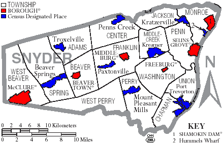
| SNYDER COUNTY |
| FORMATION: 1855 from southern Union Co. It's boundaries
have not changed since.
TOWNSHIPS as of 1990 (formation dates): Adams (1874), Beaver (1787), Center (1805), Chapman (1820), Franklin (1853), Jackson (1854), Middlecreek (1838), Monroe (1856), Penn [historically Penns/Penn's] (1758), Perry (1816), Spring (1885), Union (1869), Washington (1818), West Beaver (1843), West Perry (1858). EXTINCT TOWNSHIP (Bell 1891): Mahantango Twp. was formed in 1795 from Penn's Twp. In 1816, Mahantango Twp. ceded land to Perry Twp. and, in 1818, to Washington Twp., at which point Mahantango Twp. ceased to exist. Perry and Washington Twps. were further subdivided to form West Perry, Chapman, and Union Twps. These were among the townships ceded by Union Co. to form Snyder Co. in 1855. Therefore, inhabitants shown living in "Mahantango Twp., Northumberland Co." in the 1800 or 1810 censuses were actually living in what later became south-central and southeastern Snyder Co. BOROUGHS as of 1990: Beavertown, Freeburg,
McClure, Middleburg, Selinsgrove, Shamokin Dam.
|
| SOMERSET COUNTY |
| FORMATION: 1795 from Bedford Co.
TOWNSHIPS (as of 1990): Addison, Allegheny, Black, Brothersvalley, Conemaugh, Elk Lick, Fairhope, Greenville, Jefferson, Jenner, Larimer, Lincoln, Lower Turkeyfoot, Middlecreek, Milford, Northampton, Egle, Paint, Quemahoning, Shade, Somerset, Southampton, Stonycreek, Summit, Upper Turkeyfoot. BOROUGHS (as of 1990): Addison, Benson, Berlin, Boswell, Callimont, Casselman, Central City, Confluence, Garrett, Hooversville, Indian Lake, Jennerstown, Meyersdale, New Baltimore, New Centerville, Paint, Rockwood, Salisbury, Seven Springs, Shanksville, Somerset, Stoystown, Ursina, Wellersburg, Windber. CITIES/TOWNS/VILLAGES (according to GNIS): Acosta, Addison,
Allenvale, Althouse, Ankeny, Ashtola, Bakersville, Barronvale, Beachdale,
Beachly, Bens Creek, Benson, Berkleys Mill, Berlin, Bittners Mill, Blackfield,
Blough, Boone, Boswell, Boynton, Brotherton, Buckstown, Burkhelder, Cairnbrook,
Callimont, Casselman, Central City, Coal Junction, Coal Run, Coleman, Comps
Crossroads, Compton, Confluence, Crumb, Daley, Davidsville, Downey, Draketown,
Dumas, Edie, Engles Mill, Enoch, Fairhope, Fairview, Ferrellton, Foley,
Fort Hill, Forward, Forwardstown, Foustwell, Friedens, Gahagen, Garrett,
Gebhart, Geiger, Gideon, Glade, Glade City, Glen Savage, Glencoe, Glessner,
Goodtown, Gray, Hagero, Harnedsville, Hays Mill, Hillsboro, Hollsopple,
Hooversville, Humbert, Husband, Huston, Indian Lake, Indiantown, Jenners,
Jenners Crossroads, Jennerstown, Jerome, Jerome Junction, Jimtown, Johnsburg,
Kantner, Kennells Mill, Keystone, Kimmel, Kimmelton, Kingwood, Klines Mill,
Krings, Lambertsville, Landstreet, Laurel Falls, Laurel Mountain Village,
Laurel Summit, Lavansville, Listie, Listonburg, Macdonaldton, Mance Maple
Ridge, Markleton, Meadowdale, Metzler, Meyersdale, Milford, Mineral Spring,
Mostoller, Murdock, New Baltimore, New Centerville, New Lexington, Niver
Junction, Niverton, Ogletown, Old Shade Furnace, Paddytown, Paint, Philson,
Pilltown, Pine Hill, Pinkerton, Pleasant Union, Pocahontas, Quecreek, Ralphton,
Randolph, Reading Number Three, Reels Corners, Reitz, Roberts, Rockwood,
Rockwood Station, Romania, Rowena, Roxbury, Roytown, Rummel, Saint Paul,
Salco, Salisbury, Salisbury Junction, Sand Patch, Savage, Schweibinzville,
Scullton, Seanor, Seven Springs, Shaft, Shamrock, Shanksville, Shaw Mines,
Shober, Sipesville, Slabtown, Snydersville, Somerfield, Somerset, Springs,
Stoystown, Summit Mills, Sylvan Lane, Thomas Mill, Thomasdale, Tire Hill,
Trent, Unamis, Ursina, Warrens Mill, Wellersburg, Wells Creek, West Meyersdale,
West Salisbury, Wilbur, Williams, Wilson Creek, Windber, Wittenberg, Zimmerman.
|
| SULLIVAN COUNTY |
| FORMATION: 1847 from Lycoming Co.
TOWNSHIPS (as of 1990): Cherry, Colley, Davidson, Elkland, Forks, Fox, Hillsgrove, Laporte, Shrewsbury. BOROUGHS (as of 1990): Dushore, Eagles Mere, Forksville, Laporte.
|
| SUSQUEHANNA COUNTY |
| FORMATION: 1810 from Luzerne Co.
TOWNSHIPS (as of 1990): Apolacon, Ararat, Auburn, Bridgewater, Brooklyn, Choconut, Clifford, Dimock, Forest Lake, Franklin, Gibson, Great Bend, Harford, Harmony, Herrick, Jackson, Jessup, Lathrop, Lenox, Liberty, Middletown, New Milford, Oakland, Rush, Silver Lake, Springville, Thompson. BOROUGHS (as of 1990): Forest City, Friendsville, Great Bend, Hallstead, Hop Bottom, Lanesboro, Little Meadows, Montrose, New Milford, Oakland, Susquehanna Depot, Thompson, Union Dale. HISTORICAL NOTE: Brooklyn Twp. was known as Waterford Twp. until
the name changed in 1825.
|
| TIOGA COUNTY |
| FORMATION: 1804 from Lycoming Co.
TOWNSHIPS (as of 1990): Bloss, Brookfield, Charleston, Chatham, Clymer, Covington, Deerfield, Delmar, Duncan, Elk, Elkland, Farmington, Gaines, Hamilton, Jackson, Lawrence, Liberty, Middlebury, Morris, Nelson, Osceola, Putnam, Richmond, Rutland, Shippen, Sullivan, Tioga, Union, Ward, Westfield. BOROUGHS (as of 1990): Blossburg, Elkland, Knoxville, Lawrenceville,
Liberty, Mansfield, Roseville, Tioga, Wellsboro, Westfield.
|
| UNION COUNTY |
| FORMATION: 1813 from Northumberland. From 1771 to 1813,
the region that would become Union Co. was in Northumberland Co.
In 1813, Union Co. was formed from western Northumberland Co. The
county experienced several minor boundary changes between 1815 and 1820,
then the boundaries remained unchanged until 1855 when Snyder Co.
was formed from the southern half of Union Co. There were minor boundary
changes in 1861 and 1868, but, since 1868, the county boundaries have remained
unchanged.
TOWNSHIPS (as of 1990): Buffalo, East Buffalo, Gregg, Hartley, Kelly, Lewis, Limestone, Union, West Buffalo, White Deer. TOWNSHIP HISTORY: There is a New Columbia Twp. in Union Co. in the 1830 Census; today, New Columbia is a town on the Susquehanna River in Union Co. BOROUGHS (as of 1990): Hartleton, Lewisburg,
Mifflinburg, New Berlin.
|
| VENANGO COUNTY |
| FORMATION: 1800 from Allegheny, Crawford, and Lycoming Cos.
TOWNSHIPS (as of 1990): Allegheny, Canal, Cherrytree, Clinton, Cornplanter, Cranberry, Frenchcreek, Irwin, Jackson, Mineral, Oakland, Oilcreek, Pinegrove, Plum, President, Richland, Rockland, Sandycreek, Scrubgrass, Victory. BOROUGHS (as of 1990): Barkeyville, Clintonville, Cooperstown,
Emlenton, Franklin city, Oil City city, Pleasantville, Polk, Rouseville,
Sugarcreek, Utica.
|
| WARREN COUNTY |
| FORMATION: 1800 from Allegheny, Crawford, Lycoming, and Venango
Cos.
TOWNSHIPS (as of 1990): Brokenstraw, Cherry Grove, Columbus, Conewango, Deerfield, Eldred, Elk, Farmington, Freehold, Glade, Limestone, Mead, Pine Grove, Pittsfield, Pleasant, Sheffield, Southwest, Spring Creek, Sugar Grove, Triumph, Watson. BOROUGHS (as of 1990): Bear Lake, Clarendon, Sugar Grove, Tidioute,
Warren city, Youngsville.
|
| WASHINGTON COUNTY |
| FORMATION: 1781 from Westmoreland Co.
TOWNSHIPS (as of 1990): Amwell, Blaine, Buffalo, Canton, Carroll, Cecil, Chartiers, Cross Creek, Donegal, East Bethlehem, East Finley, Fallowfield, Hanover, Hopewell, Independence, Jefferson, Morris, Mount Pleasant, North Bethlehem, North Franklin, North Strabane, Nottingham, Peers, Robinson, Smith, Somerset, South Franklin, South Strabane, Union, West Bethlehem, West Finley, West Pike Run. HISTORICAL: There was an East Pike Run in the 1840 Census. BOROUGHS (as of 1990): Allenport, Beallsville, Bentleyville, Burgettstown,
California, Canonsburg, Centerville, Charleroi, Claysville, Coal Center,
Cokeburg, Deemston, Donora, Dunlevy, East Washington, Elco, Ellsworth,
Finleyville, Green Hills, Houston, Long Branch, McDonald, Marianna, Midway,
Monongahela city, New Eagle, North Charleroi, Roscoe, Speers, Stockdale,
Twilight, Washington city, West Alexander, West Brownsville, West Middletown.
|
| WAYNE COUNTY |
| FORMATION: 1798 from Northampton Co.
TOWNSHIPS (as of 1990): Berlin, Buckingham, Canaan, Cherry Ridge, Clinton, Damascus, Dreher, Dyberry, Lake, Lebanon, Lehigh, Manchester, Mount Pleasant, Oregon, Palmyra, Paupack, Preston, Salem, Scott, South Canaan, Sterling, Texas. BOROUGHS (as of 1990): Bethany, Hawley, Honesdale, Prompton, Starrucca,
Waymart.
|
| WESTMORELAND COUNTY |
| FORMATION: 1773 from Bedford Co.
TOWNSHIPS (as of 1990): Allegheny, Bell, Cook, Derry, Donegal, East Huntingdon, Fairfield, Hempfield, Ligonier, Loyalhanna, Mount Pleasant, North Huntingdon, Penn, Rostraver, St. Clair, Salem, Sewickley, South Huntingdon, Unity, Upper Burrell, Washington. BOROUGHS (as of 1990): Adamsburg, Arnold city, Arona, Avonmore,
Bolivar, Delmont, Derry, Donegal, East Vandergrift, Export, Hunker, Hyde
Park, Irwin, Jeannette city, Latrobe, Laurel Mountain, Ligonier, Lower
Burnell city, Madison, Manor, Monessen city, Mount Pleasant, Municipality
of Murrysville, New Alexandria, New Florence, New Kensington city, New
Stanton, North Belle Vernon, North Irwin, Oklahoma, Penn, Scottdale, Seward,
Smithton, South Greensburg, Southwest Greensburg, Sutersville, Trafford,
Vandergrift, West Leechburg, West Newton, Youngstown, Youngwood.
|
| WYOMING COUNTY |
| FORMATION: 1842 from Luzerne Co.
TOWNSHIPS (as of 1990): Braintrim, Clinton, Eaton, Exeter, Falls, Forkston, Lemon, Mehoopany, Meshoppen, Monroe, Nicholson, North Branch, Northmoreland, Noxen, Overfield, Tunkhannock, Washington, Windham. BOROUGHS (as of 1990): Factoryville, Laceyville, Meshoppen, Nicholson,
Tunkhannock.
|
| YORK COUNTY |
| FORMATION: 1749 from Lancaster Co.
TOWNSHIPS (as of 1990): Carroll, Chanceford, Codorus, Conewago, Dover, East Hopewell, East Manchester, Fairview, Fawn, Franklin, Heidelberg, Hallam/Hellam, Hopewell, Jackson, Lower Chanceford, Lower Windsor, Manchester, Manheim, Monaghan, Newberry, North Codorus, North Hopewell, Paradise, Peach Bottom, Penn, Shrewsbury, Springettsbury, Springfield, Spring Garden, Warrington, Washington, West Manchester, West Manheim, Windsor, York. BOROUGHS (as of 1990): Cross Roads, Dallastown, Delta, Dillsburg,
Dover, East Prospect, Fawn Grove, Felton, Franklintown, Glen Rock, Goldsboro,
Hallam/Hellam, Hanover, Jacobus, Jefferson, Lewisberry, Loganville, Manchester,
Mount Wolf, New Freedom, New Salem, North York, Railroad, Red Lion, Seven
Valleys, Shrewsbury, Spring Grove, Stewartstown, Winterstown, Wrightsville,
Yoe, York city, Yorkana, York Haven.
|
| Contact | Home Page |
Table of Contents |
DNA Hub |
Biddle DNA |
Carrico DNA |
Corbin DNA |
Cupp DNA |
Danish DNA |
Ely DNA |
Lyon(s) DNA |
Rasey DNA |
Reason DNA |
Rose DNA |
Straub DNA |
Pedigree Charts |
Census Records |
Every-Name Indices |
| "The Cloud" is double-speak for "dumb terminal
on a main frame." Been there; done that. Never again.
You are giving away not only your privacy, but control of your data, your apps, and your computer to a corporation. Is that really where you want to go? The IT guys on the big iron hated the Personal Computer because it gave users freedom and power; now they've conned you into being back under their control. |
| Table of Contents
|
Privacy
Policy ______
|
Every-Name Index
|
-